


|
|
|
|
||
|
||
|
||
|
||
|
||
|
||
The Edgware Eruv covers parts of
postcodes HA8 and NW7.
Use the search form below to find if a
certain road
in either of these postcodes
is included in the Eruv.
Use 4 letters or more and do not use
abbreviations. For example use
road NOT rd and street NOT st.
However, DO use st for saint.
You are best using parts of street names.
For example to find Broadfields Avenue
just try broad or fields
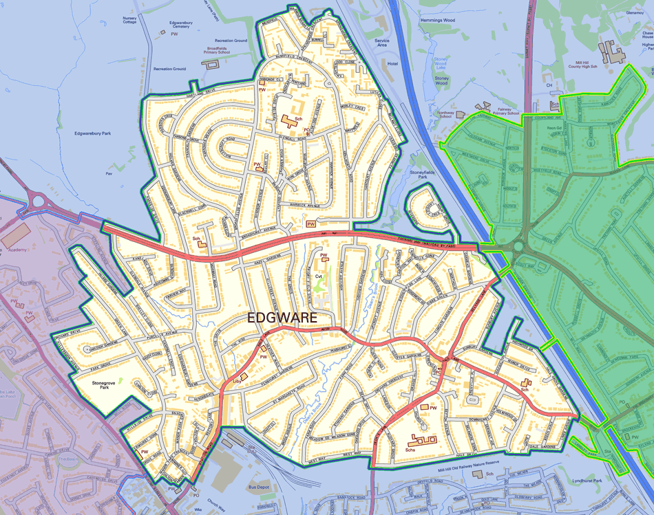
A map showing the roads included within
the Edgware Eruv
is shown below.
This is also available as a Google map with
surrounding Eruvin indicated.
Please Note
Both Edgwarebury Park and Stoneyfields Park
are completely outside of the Eruv. Stonegrove
Park is inside the Edgware Eruv and the park
gate on Stonegrove marks the boundary between
the Edgware Eruv (in the park) and the Stanmore
Eruv (on Stonegrove).
On Station Road Edgware, the Edgware Eruv stops
before the old Post Office (just beyond the entrance
to the Broadwalk carpark).
Neighbouring Eruvin
The Edgware Eruv is bordered by two neighbouring
Eruvin, Stanmore and Mill Hill. Where the Edgware
Eruv joins one of its neighbours, one may choose to
carry from one to the other. However, the Edgware
Eruv is independent and its status does
not rely on
the validity of any other Eruv. The Stanmore Eruv
and Mill Hill Eruv are under
the halachic supervision
of the London Beth
Din and
further
details can be
found at:
www.stanmore-eruv.org.uk
www.millhilleruv.com
Edgware/Stanmore border
The A5, Edgware High Street, also known as
Stonegrove is always
completely outside of
the
Edgware Eruv and all houses and
buildings
opening
onto it are also completely outside of the
Edgware Eruv. Note that some of Stonegrove is
within the Stanmore Eruv.
The pedestrian overpass on the A41
Edgware
Way, just by the
entrance to Edgwarebury Park, is
outside of
the Edgware Eruv but is within the
Stanmore Eruv.
Care should be taken when walking to Stanmore
as neither Green Lane nor the A41 links the
Edgware Eruv to the Stanmore Eruv. The only link
is via Stonegrove.
Edgware/Mill Hill border:
There are four crossing points between the Edgware
and Mill Eruvin:
Care should be taken when walking through Mill Hill
towards Hendon
as the middle of Bunns Lane is in
neither the Edgware Eruv nor the Mill Hill Eruv.
There is an alternative route via Woodland Way
and Flower Lane.
Click the map to Zoom in
also available as a Google map with surrounding Eruvin indicated
Click the map to Zoom in
also available as a Google map with surrounding Eruvin indicated
Map Contains Ordanance Survey data © Crown copyright and database right 2011
Please see our Privacy Notice